
A climate-change-triggered landslide caused Earth to vibrate for 9 days
Belgian researchers are involved in a study lead by an international multidisciplinary team
In September 2023, a mysterious, globally observed and unprecedented 9-day-long seismic signal was caused by a massive landslide in Greenland. 25 million m³ of rock and ice fell into the Dickson Fjord and, in turn, caused a 200-metre-high mega-tsunami that continued sloshing back and forth – a phenomenon called a seiche – in the narrow fjord for 9 days. That is the conclusion of research published in the journal Science. The seismic waves generated by this large mass of moving water have been observed around the world. Never before have scientists, including researchers of the Royal Observatory of Belgium (ROB), the Flanders Marine Institute (VLIZ) and the Université libre de Bruxelles (ULB), observed such an unusual mechanism causing a global seismic signal.
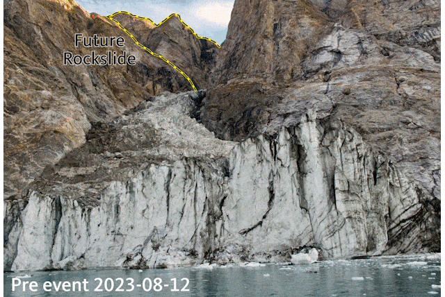
GIF-animation of the Before (August 2023) and after (September 2023) photos of the mountain peak and glacier, taken from the Dickson Fjord. Source image credits: Søren Rysgaard, Danish Army. GIF-animation: Carsten E. Thuesen.
A Puzzle solved within a multidisciplinary collaboration
The mysterious 9-day-long seismic signal, which started on 16 September 2023 and was recorded on highly sensitive sensors all over the globe, puzzled seismologists from ROB and ULB. The signal looked completely different to frequency-rich earthquake recordings – it contained only a single vibration frequency, like a monotonous-sounding hum. At the same time, news of a large tsunami in a remote Northeast Greenland fjord reached authorities and researchers from VLIZ working in the area.
Both teams joined forces with a multidisciplinary international group of 68 scientists from 40 institutions in 15 countries, combining seismometer and infrasound data, unique field measurements, on-the-ground and satellite imagery, and simulations of tsunami waves.
Animated, sonified seismic signal (seismic waves sped up and converted to audible frequencies) as recorded by a seismic station in Greenland, DK.SCO.
The team also used imagery captured by the Danish military who sailed into the fjord just days after the event to capture the collapsed mountain-face and glacier front along with the dramatic scars left by the tsunami. This unique harmony of local field data and remote, global-scale observations allowed the team to solve the puzzle and reconstruct the extraordinary cascading sequence of events in September 2023. The results are now published in Science.
A huge landslide collapsing into a narrow fjord as the origin of the seismic waves
The local signal was picked up by a real time monitoring network set up in the Kong Oscar Fjord System by VLIZ and Aarhus University, including cameras and oceanographic moorings, to study climate gradients and freshwater dynamics. Oceanographic sensors in Dickson Fjord and near Ella Ø measured anomalous water levels and peak turbidity. The global seismic signal was picked up by a global network of seismometers; sensitive scientific instruments that record vibrations travelling through the ground – called seismic waves.
Traditionally, seismology focuses on measuring seismic vibrations arising from earthquakes in the ground. However, seismic records can also contain information about movements of large masses on Earth’s surface, such as landslides and water waves.
The study found that the landslide was from the collapse of a mountaintop that previously towered 1.2 km above the Dickson Fjord. The volume of material that collapsed was massive – more than 25 million cubic metres – or 27 times the volume of all 20 ft containers on world’s largest container vessels (circa 24 000 per vessel or 650 000 containers). This collapse was caused by glacial thinning at the base of the mountain over recent decades, ultimately caused by climate change.
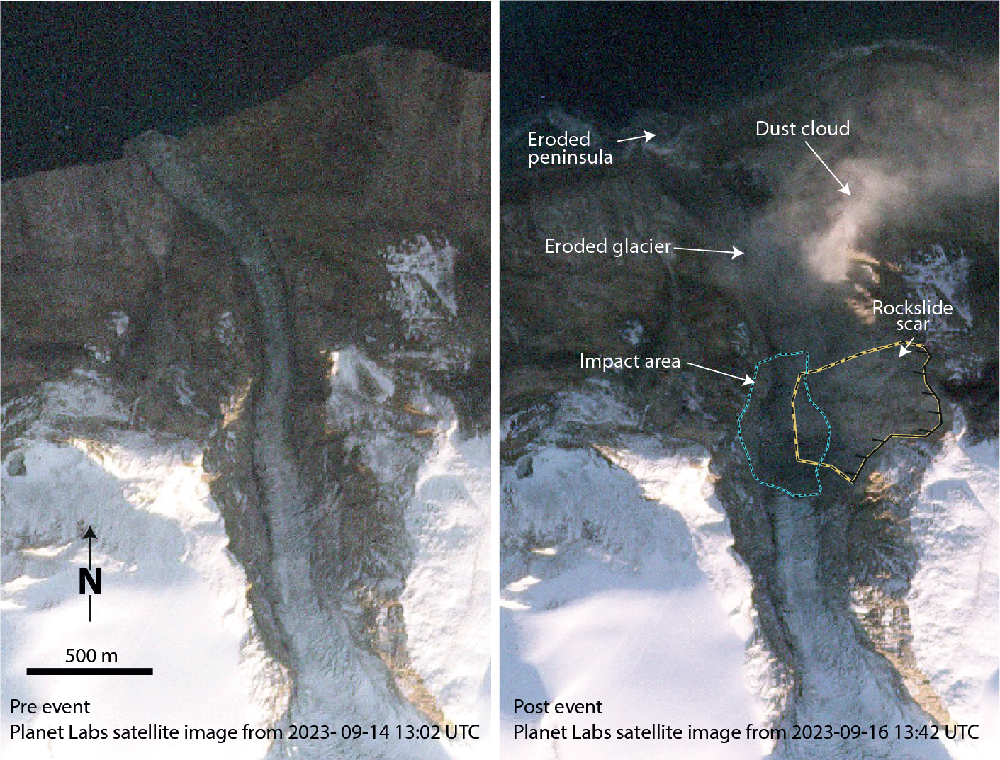
Pre- (30 minutes before) and post-landslide (7 minutes after) Planet Labs satellite image
The combined signals were so puzzling, that one of the scientific team members tried to recreate the long-lived sloshing effect in their bathtub at home. They failed to simulate the same effect, so it was left to detailed mathematical models to show that the landslide direction, together with the uniquely narrow and bendy fjord channel, was the last missing piece of the puzzle of how climate change rang the Earth for 9 days.
The predictions showed that water sloshed back and forth every 90 seconds, the same oscillation period observed in the seismic waves. This perfect match shows how the force of the moving water body, generating a distinct oscillation due to the width and depth of the fjord, creates seismic energy in the crust.
The left panel shows a ground motion visualisation, showing the seismic wave from the Greenland seiche spreading out around the planet. Each circle shows the data from an individual seismic monitoring station. The right panel shows a numerical simulation of the 16 September 2023 tsunami and seiche (oscillation wave) in Dickson fjord(music credit: Isabelle Ryder https://isabellerydermusic.weebly.com/; animation credit: Stephen Hicks).
Co-author Thomas Lecocq (Royal Observatory of Belgium, ROB) says: “Our initial estimates of its source position centred on East-Greenland. At the same time, Greenlandic and Danish authorities received reports of a large tsunami at the (then unoccupied) Nanok station and research base at Ella Island. As an interdisciplinary and international research team, we have integrated all the information to present a detailed reconstruction of the first documented large, tsunamigenic landslide for East-Greenland and how it generated global very long-period seismic signals. It’s amazing that what started as a routine check of a Belgian gravity sensor turned into a global, multi-disciplinary collaboration, with virtual, online exchanges over 24/7, covering many time zones. I’m happy we proved the source of the vibrations was water sloshing, and that this adventure led to new collaborations with colleagues all over the world, including Wieter Boone from VLIZ who is now installing seismic instruments from the ROB in Dickson Fjord to further advance our understanding of this unique area”.
The highest tsumani observed in recent history
Numerical simulations, data from a local oceanographic sensor network, satellite and on-the-ground imagery confirm that the resulting mega-tsunami is one of the highest seen in recent history. Further out of the fjord, 4 m high tsunami waves damaged a research base at Ella Ø (island) 70 km away and destroyed cultural and archaeological heritage sites across the fjord system. The fjord is on a route commonly used by tourist cruise ships visiting the Greenland fjords.
Fortunately, no cruise ships were close to Dickson Fjord on the day of the landslide and tsunami, but if they had been, the consequences of a tsunami wave of that magnitude could have been devastating. With rapidly accelerating climate change, it will become more important than ever to characterise and monitor regions previously considered stable and provide early warning of these massive landslide and tsunami events.
Co-author Wieter Boone (Flanders Marine Institute, VLIZ): “For our research, we established a network of real time under ice oceanographic stations in Northeast Greenland. Last year, we sailed into Dickson Fjord to install instruments close to a glacier and almost right in front of the mountain just weeks before it collapsed. Our instruments survived and we were able to follow the events unravel in real time. The observed destruction of an old trapper hut, never affected by tsunamis for its century-old history, demonstrate the unexpected size of this event. During August 2024, we updated our sensor network, mapped the impact of the tsunami using drones and installed high frequency seismic and water level sensors in Dickson Fjord.”
The research paper:
Svennevig et al., A rockslide-generated tsunami in a Greenland fjord rang Earth for 9 days, Science, published online on 12 September 2024. DOI: 10.1126/science.adm9247.